There is a GeoSpatial LA meeting tomorrow, including a Red Cross EOC tour. For more info see http://egis3.lacounty.gov/eGIS/2013/05/23/geospatial-la-gathering-may-30th/ .
GeoSpatial LA Meeting
Reply

There is a GeoSpatial LA meeting tomorrow, including a Red Cross EOC tour. For more info see http://egis3.lacounty.gov/eGIS/2013/05/23/geospatial-la-gathering-may-30th/ .
Here is the link to the Forum’s website: www.esri.com/3Dforum
Learn new 3D webmap: http://dld.bz/c9sJB (works best in Chrome)

Preliminary Agenda:
| Sunday, July 7, 2013 | ||
| 8:00 a.m. – 8:10 a.m. | Welcome and Introductions Steve Snow, MAPS Industry Specialist | |
| 8:00 a.m. – 8:30 a.m. | Esri 3D Imagery Future Possibilities Lawrie Jordan, Esri, Director of Imagery |
|
| 8:30 a.m. – 9:30 a.m. | Lidar and ArcGIS: Recent Advances and the Road Ahead Clayton Crawford, Esri Product Engineer |
|
| 9:30 a.m. – 10:00 a.m. | 3D Mapping and GeoDesign Gert van Maren, Esri, Head of Product Management |
|
| 10:00 a.m. – 10:15 a.m. | Gold Sponsor Speaking Slot | |
| 10:00 a.m. – 10:30 a.m. | Break | |
| 10:30 a.m. – 11:00 a.m. | Lidar and Imagery in ArcGIS 10.1 Cody Benkelman, Esri Product Manager |
|
| 11:00 a.m. – 11:20 a.m. | Leveraging data attributes populated from Lidar with CityEngine Geoff Taylor, Solutions Engineer |
|
| 11:20 a.m. – 11:40 a.m. | An update on the American Society for Photogrammetry and Remote Sensing (ASPRS) LIDAR Data Standard Lewis Graham, ASPRS Regional Director |
|
| 11:40 a.m. – 12:00 p.m. | Lunch and Platinum Speaker: Optech Title TBA Jim Green, Regional Manager, North America, Airborne Survey Products |
|
| 12:00 p.m. – 1:00 p.m. | Lunch sponsored by Optech with exhibitors Exhibition area |
|
|
|
Breakout |
Breakout |
Breakout |
| Topic: | Unmanned Aerial Vehicles and Mobile Mapping | Smart 3D Cities | Military Installation 3D Management |
| Moderator: | Myles Sutherland | Chris Wilkins | Terry Martin |
| 1:00 p.m. – 1:15 p.m. | Introduction | Introduction | Introduction |
| 1:15 p.m. – 1:45 p.m. | Panel Discussion (TBD) | The Instant City Elliot Hartley, Garsdale Design Ltd. |
User Speaker (TBD) |
| 1:45 p.m. – 2:15 p.m. | Panel Discussion (TBD) | Master Plan for 500K Tal Aisenberg, WATG |
User Speaker (TBD) |
| 2:15 p.m. – 2:30 p.m. | Hawkeye Rowland Harrison |
Geospecific City Modeling Sponsor, Kevin Devito, CyberCity3D |
Sponsor Speaker (TBD) |
| 2:30 p.m. – 3:00 p.m. | SenseFly Andrea Hildebrand |
Immersive City Visualization David Burdick, E-on Software |
User Speaker (TBD) |
| Each breakout session will contain 1 sponsor speaker with 15 minute speaking slot and 3 user speakers with 30 minute speaking slot each. | |||
| 3:00 p.m. – 3:15 p.m. | Break |
| 3:15 p.m. – 3:30 p.m. | Gold Sponsor Speaker |
| 3:30 p.m. – 4:00 p.m. | User Speaker |
| 4:00 p.m. – 4:30 p.m. | User Speaker |
| 4:30 p.m. – 4:45 p.m. | Closing |
| 5:00 p.m. – 6:30 p.m. | Break |
Hello CA GIS users,
As you may be aware, the California Ocean Protection Council, in partnership with USGS and NOAA Coastal Services Center, funded a LiDAR data collection effort along the California coast and San Francisco Bay, between 2009-2011. The data were made available last year through the NOAA Coastal Service Center’s Digital Coast Data Access Viewer.
The entire LiDAR dataset is now available for download via an ftp/http directory from the NOAA Coastal Service Center’s Digital Coast Data Registry. The data are packaged as .laz files. Please read the 0README file in the directory for instructions on how to download. For technical questions, please contact NOAA CSC staff, Keil Schmid at keil.schmid@noaa.gov.
The Ocean Protection Council is looking for illustrated examples of how the LiDAR data are being used. This can be an image, map, figure, etc you developed based on the LiDAR or DEMs. We would like to use these illustrated examples in future presentations about how the LiDAR and derived products are applied. If you are able, please email me a screen capture or small jpeg for use in presentations, with your permission.
Thank you,
Clare
—————————————-
Clare O’Reilly
Project Manager, Ocean Protection Council
State Coastal Conservancy
1330 Broadway, Floor 13; Oakland, CA 94612-2530
phone 510-286-0332 / fax 510-286-0470
coreilly@scc.ca.gov
OceanSpaces is live! Join the online community that brings people together who care about California’s oceans. www.oceanspaces.org

Google has rebuilt Maps from the “ground up”, with a new interface, search abilities, and faster performance. Check it out at http://maps.google.com/preview .
Google Maps will be based on vector imagery delivered via WebGL. Maps will also include 3D photographic imagery for some locations and user-uploaded photos.
Google has also updated its mobile apps for iOS and Android, which includes traffic alerts with live accident information and rerouting capabilities. An iPad version will also be released this summer.
We had a great meeting last week. Thanks goes to Culver City for hosting … and the snacks too!
Meeting presentations and pictures have been posted on our Meetings page. Also, we are looking for someone to host our next meeting in the Fall/Winter. Please contact us if you want to host.
The Ordnance Survey has a great posting of online resources for map design. Resources for colors, fonts, symbols, and inspiration. Check it out.
Just a reminder that our next SoCalGIS meeting will be tomorrow, May 9th, at the City of Culver City. More details and agenda on our Meetings page.
If you have not done so already through email or meeting invite, contact Michael Carson at mcarson@burbankca.gov and let him know you will be attending. This will help us get an accurate count for refreshments.
Hope to see you there!
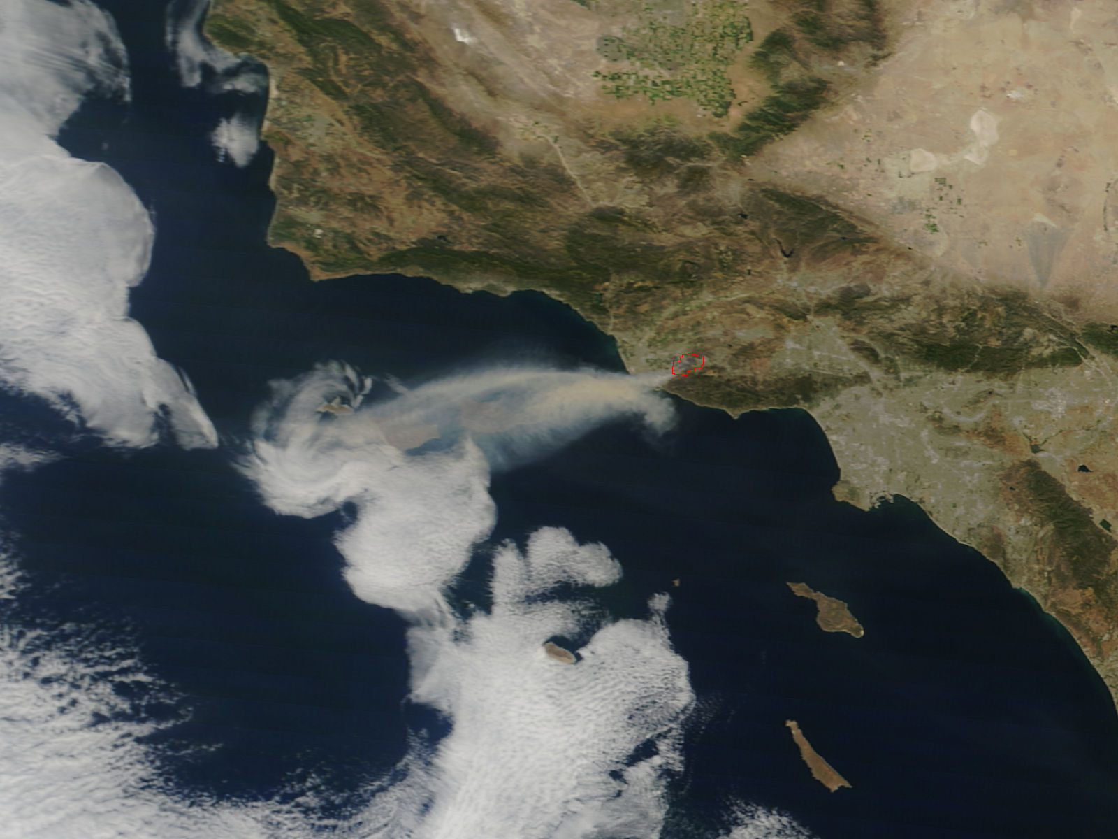
NASA’s Earth Observing System Data and Information System (EOSDIS) has some current images of the Springs Fire.
Android and iPhone users can now use their mobile devices as digital topo maps, leveraging USGS maps together with the power of GPS to zoom in on their precise location while hiking, biking, running, or any other activity that benefits from precision navigation.
The type of data that are available includes USGS imagery and topographic maps from The National Map, as well as road and contour layers. For more info, visit http://www.usgs.gov/newsroom/article.asp?ID=3580 .
Kenneth Appel, who used a computer to solve the four color map problem, dies at 80.

