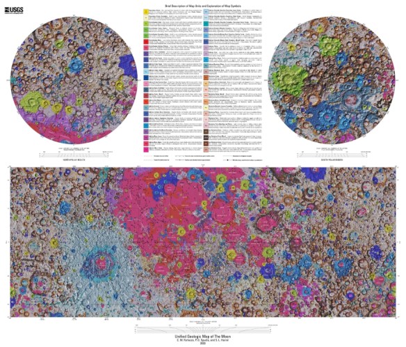
USGS First Complete Geologic Map of the Moon

The USGS has released the first unified geologic map of the moon.  This new work represents a seamless, globally consistent, 1:5,000,000-scale geologic map derived from the six digitally renovated geologic maps. The goal of this project was to create a digital resource for science research and analysis, future geologic mapping efforts, be it local-, regional-, or global-scale products, and as a resource for the educators and the public interested in lunar geology.  Click below to check it out!

moongeologicmap

Free Access to Nearmap for Government

The aerial imagery company Nearmap announced today that it is making its high-resolution aerial imaging available free of charge to state, local, and county health officials and government agencies for COVID-19 relief effort planning. Agencies that do not currently have access to an active Nearmap subscription or trial can request this service immediately by visiting Nearmap’s website or calling 801-292-2321.

US Census Knowledge Quiz

What role do postal carriers play in census preparations? What new response category will be featured on this year’s census form? Test your Census expertise on these questions and more with the Pew Research Center’s U.S. Census Knowledge Quiz. The 12-question quiz covers the history, purpose, and changes to the U.S. Census and provides test-takers with answers and explanations immediately following their attempt.

Readers who are displeased with their results may want to sign up for the Pew Research Center’s “short email mini course” on the U.S. Census (accessible by clicking the linked text “email mini-course”). This free course is divided into five sections including “What is the census and why is it taken?” and “What is new and possibly challenging about the 2020 census?” Enrolled users will receive “an email with a lesson every few days,” allowing for a manageable way to better understand why this data collection process is so important.

If you are stuck at home with kids right now, a great teaching tool too!  Check it out by clicking here.

Also check out the Census Historical Timeline.  AND check out the 1940 Census website.  You can search for images of the pages people signed.  I was able to find my Grandparents who also listed my father and his sister when they were children, pretty cool!

Security Issue in ArcGIS Server

ESRI has discovered a critical vulnerability in the ArcGIS Server component of ArcGIS Enterprise resulting in a Server Side Request Forgery (SSRF) issue when special steps are taken by someone with network access to the deployment. This can result in access to and control over other infrastructure resources by unauthenticated persons.

This security issue affects all supported versions prior to ArcGIS Server 10.8 on both Windows and Linux.  Click here for more info and how to fix.