Check out this interactive map showing light pollution from urban centers around the world. Light pollution at night can blot out the stars, so the brighter the area, the harder it is to see stars in the night sky.


Check out this interactive map showing light pollution from urban centers around the world. Light pollution at night can blot out the stars, so the brighter the area, the harder it is to see stars in the night sky.
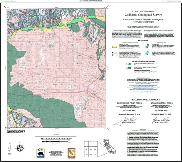
The Alquist-Priolo Earthquake Fault Zone Act (1972) and the Seismic Hazards Mapping Act (1990) direct the State Geologist to delineate regulatory “Zones of Required Investigation” to reduce the threat to public health and safety and to minimize the loss of life and property posed by earthquake-triggered ground failures. Cities and counties affected by the zones must regulate certain development “projects” within them. These Acts also require seller of real property (and their agents) within a mapped hazard zone to disclose at the time of sale that the property lies within such a zone.
The California Geological Survey has released 7 new Alquist-Priolo Earthquake Fault Zone maps in the San Bernardino County and Tahoe Basin areas. Check it out.
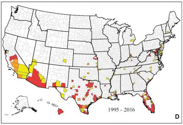
A new map showing where mosquitoes that can carry the Zika virus include 40 states and Washington D.C. The map was compiled by experts at the Centers of Disease Control and Prevention. The CDC used records from their mosquito-borne disease database, mosquito control agencies, university researchers and state and local health departments. Click the map to read the article.
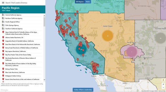
The Bureau of Indian Affairs (BIA) first developed the Tribal Leaders Directory as an internal reference document for its employees. It quickly became one of Indian Affairs’ most requested documents, and is now used by federal, state and local governments, news media, businesses, researchers, and the general public as a resource to help them connect with Indian Country. The BIA’s commitment to enhanced communication led to transforming this publication into the electronic interactive map. Check it out.
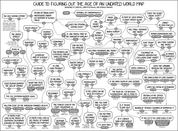
Fantastic flowchart by xkcd showing how you can determine the age of an undated world map … or sometimes not!
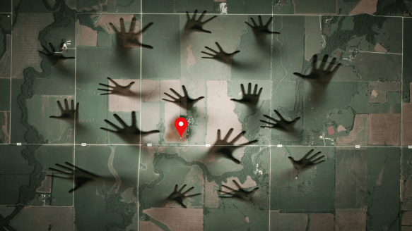
Beware of IP address mapping companies. They might be pointing to your house and make your life a living hell.
Just received an email that ArcGIS 10.4.1 is now available to download. If you have current maintenance, you can download it from https://my.esri.com.
Here is a list of issues addressed in the 10.4.1 release.
Jeff Orton, the President of Central Cal URISA, did a brief write-up on the CalGIS conference in Anaheim. Check it out.
Our next stop for California Friday is Gravity Hill in Sylmar. For those of you that grew up in the San Fernando Valley, you probably remember going to Gravity Hill to experience your car rolling “uphill” without any power. To make it extra creepy, it was best to experience this phenomena in the dark of night because Gravity Hill was next to a cemetery. Then add in a legend about a school bus crash that happened there and the children that died will push your car to keep you from the same fate … that makes it even more creepy! Continue reading
Didn’t get to go to the ESRI Developer Summit in Palm Springs? Here is a recap of the top technology takeaways with some videos as well. Looks like ArcGIS API 4.0 for JavaScript and Vector Tile Maps will be a big thing this year. Check it out.