The 2018 ESRI User Conference in San Diego is rapidly approaching. Is your government agency sending you to the conference this year? Why not attend the State and Local Government Social at the Hilton on Wednesday, July 11 from 6-8pm? Hope to see you there!
Author Archives: socalgovgis - Michael Carson
GIS Meme
This one made me laugh!

Spaces in file names were a big problem with my GIS students.
Why Aerial Imagery Resolution Matters
Just found this interesting article about why you want the highest resolution imagery possible for your projects. Check it out.
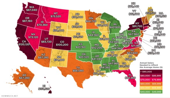
Salary Needed to Buy a Home
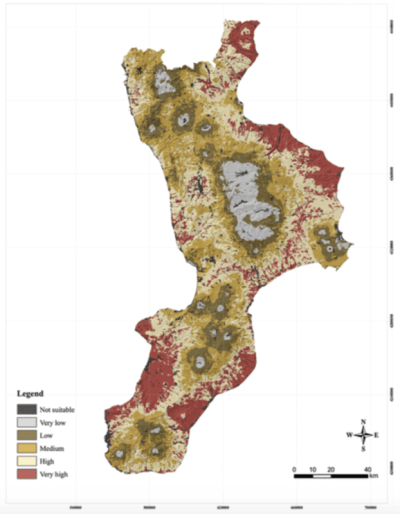
Bee Migration Mapping
Free ESRI Public Safety Webinars
ESRI is hosting a webinar series dedicated to the trends, technical advancements, best practices, and special topics relating to GIS in public safety. Each webinar highlights a different subject relevant to your organization’s missions, workflows, and operations. Upcoming webinars include the following:
- ESRI Law Enforcement Webinar Series: Introduction to the New ArcGIS Pro Add-In to Support Crime Analysis Workflows, June 7, 2018, 9:00 a.m.–10:00 a.m. (PDT)
- ESRI National Security Webinar Series: Indoors and Outside—Securing Critical Facilities and Workplaces, June 13, 2018, 9:00 a.m.–10:00 a.m. (PDT)
- ESRI Fire and EMS Webinar Series: Ventura County Fire’s Response to the Thomas Fire Using GIS, June 20, 2018, 9:00 a.m.–10:00 a.m. (PDT)
Visit the ESRI Public Safety Webinar Series website to register for upcoming events and stay up to date with GIS solutions for public safety agencies.
spatial@ucsb.local2018
CGIA Board Nominations Are Open
The California Geographic Information Association (CGIA) Board nominations are still open, but will close at the end of the day tomorrow. Nominate yourself or someone that would like to run for the following openings:
Board Officer positions open for nominations:
- Chair
- Vice Chair
- Secretary
Board Member Categories open for nomination:
- Federal Government
- City Government
- Regional Governments and Districts
- State Governments
- Education
- Private Sector Companies
- Professional Societies and Not-for-Profits.
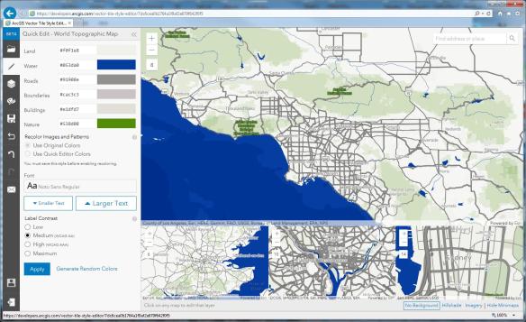
ArcGIS Vector Tile Style Editor
ESRI has announced the release of the ArcGIS Vector Tile Style Editor, available in beta on the ArcGIS for Developers website. The tool gives you a fast and easy way to create a custom basemap style.
By selecting an existing vector basemap, you can customize the layer colors and labels. You can edit everything from fill and text symbols to fonts, halos, patterns, transparency, and zoom level visibility. When you are finished, the styles are saved as an item in ArcGIS Online with a unique ID. The map viewer or any custom application can then reference the ID to display the basemap. Check it out.