Orange County has a new Open Data Portal. You can explore by categories, like boundaries, cadaster, environment, health, infrastructure, etc., or just type a search, like “parcels” or “street centerlines”. There are also links to feature apps and paper maps too. Check it out!
Author Archives: socalgovgis - Michael Carson
ArcGIS Online Update
For those of you that use ESRI’s ArcGIS Online product, they just announced that they plan on updating it on September 18. Here are four capabilities you can check out once the update happens: Continue reading
Mapping Global Debt
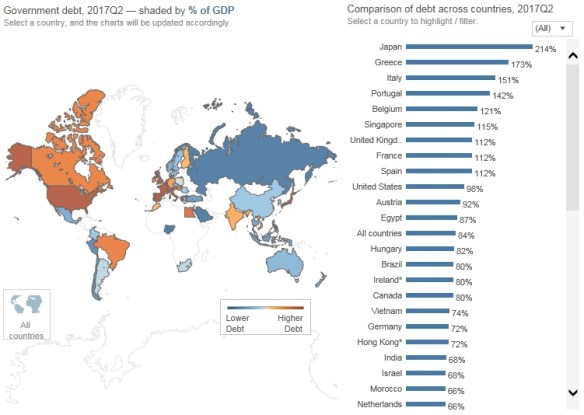
Check out this interactive map that visualizes the debt of 51 different countries around the world. The map provides a choropleth view of how much debt is held by each country since 2000 and how that debt has progressed since the global financial crisis of 2008. You can also visualize household debt, which includes things like mortgages, student loans, and consumer credit.
2018 ESRI Conference Technical Workshops
Did you miss a few technical workshops at the 2018 ESRI User Conference? Good news, there are many to watch now on ESRI’s youtube site. Check it out!
New Features in Operations Dashboard
Operations Dashboard for ArcGIS is a configurable web app that is included with your ArcGIS Online subscription and/or ArcGIS Enterprise software. The app provides location-aware data visualization and analytics for a real-time operational view of assets, people, services, and events. Click below to find out about the top six new features.
Also check out this blog post about strategies and best practices for using dashboards on your smartphone.
Tech Behind Wildfire Story Map
Pay for Google Street View?
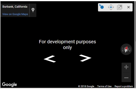
Like many of you, you might be using the Google API in your Geocortex apps so you have access to the Google Street View tool. Well, for us it stopped working recently:

We found out that Google changed their API terms of use this summer. They have stopped supporting keyless usage. That means you cannot access Google Street View through your apps without a billing account and an API key. Keyless calls to the Maps JavaScript API and Street View API will return low-resolution images watermarked with “for development purposes only.” You do not have to worry about this if you use the Google Maps website and Street View there. This is only through API interfaces.
2018 ESRI UC Proceedings
The 2018 ESRI User Conference Proceedings are now available online. You can access papers and presentation materials from GIS professionals who shared best practices and case studies at the conference. Check it out!
Map of California Wildfires and CO
Deep Learning and ArcGIS using Python
ESRI has an upcoming GeoDev Webinar about Integrating Deep Learning with ArcGIS using Python (August 24th). This webinar will showcase examples of applying Artificial Intelligence, Machine Learning, and Deep Learning to geospatial data using ArcGIS API for Python. It will cover several scenarios of applying the latest machine learning and deep learning techniques to geospatial data. Sign up today!