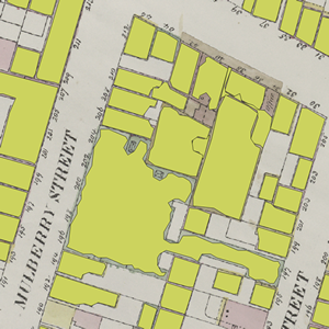
Have some paper maps that you need to extract features for GIS … and attributes as well? Check this work out by NYPL Labs on GitHub!
Author Archives: socalgovgis - Michael Carson
SoCal URISA Seminar – ESRI and Open Source Web Mapping
Upcoming event information:
So Cal URISA – ESRI and Open Source Web Mapping ESRI, Redlands, CA
Date: 22 Oct 2013 9:00 AM
Schedule
8:30am – 9:00am: Arrival and networking
9:00am: Start
9:00am – 10:30am: ESRI – Web Mapping, Ryan Hunsicker – MapBox
10:30am – 10:45am: Networking Break
10:45am – 12:00pm: 2 Presentations 1/2 Hour each or 6 Lightning Talks – 10 Minutes each
ESRI Campus Tour – Limit 12
Location:
ESRI Headquarters
380 New York Street
Redlands, CA 92373
Check in at main lobby in Building Q
Free to So Cal URISA Members
For more information and to register online: http://socalurisa.org/Events_201310_ESRI_WebMap.html
If you are interested in presenting for either a 1/2 hour or giving a lightning talk, we still have spots to fill. If you are interested in either, please contact Ryan Hunsicker.
Best regards,
Southern California Chapter of URISA
CPAD – California’s Protected Areas Database
GreenInfo Network’s CPAD has been updated and is ready for download or use through a web service – go to www.CALands.org for details. The new data set expands the number of agencies with holdings to almost 1,000 and adds significantly in San Diego County, plus many other improvements. This data version (CPAD 2013b) also has more detailed subtypes for agencies (you can now query for “Land Trusts” and other sub types), and an initial default Gap (biodiversity) rank field. You can review and comment on the data, and take a simple online evaluation survey at www.CALands.org/revise. Questions? Send email to cpad@calands.org.
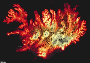
Mesmerizing Iceland Map Puts a Volcano in Your Pocket
Broadcast maps for NFL, College Football, and MLB
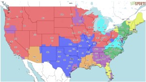
Interesting maps showing broadcast areas for NFL, College Football, and MLB games.
Thanks goes to Tom Lutgen at Burbank Water & Power for finding this site. He poses the question “Interesting to see the market boundaries for each team – like, why is San Diego the only SoCal market to get the Atlanta-Miami game on Fox? Advertising bucks at play I suppose”.
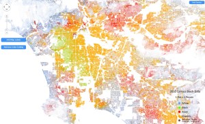
The Best Map Ever Made of America’s Racial Segregation
Last year, a pair of researchers from Duke University published a report with a bold title: “The End of the Segregated Century.” U.S. cities, the authors concluded, were less segregated in 2012 than they had been at any point since 1910. But less segregated does not necessarily mean integrated–something this incredible map makes clear in vivd color. Read the Wired article here.
Thanks to Mike Mercurio’s GIS student Alexi Elconin for finding this one!
Sharpen Your GIS Skills Seminar
As a GIS professional, you have to maintain your edge. Esri invites you to hone your tradecraft at the Sharpen Your GIS Skills seminar. This free, half-day event will show you best practices to accomplish your tasks and update your workflows to increase your effectiveness.
Attend this seminar to do the following:
- Learn how and when to use basic to complex analysis tools to drive better decision making
- Find out about the wealth of data, templates, and other resources available for your projects
- Get ideas for extracting more value and better information from your existing software and data
- Increase your knowledge of the latest GIS tools and how you can take advantage of them
- Expand your professional network by meeting Esri staff and others who are using ArcGIS to solve similar challenges
Space is limited. Find the seminar location in your area and register today! NOTE: For those in the SoCal area, there is one on October 1, 2013 in Anaheim.
California as an Island
The Glen McLaughlin Map Collection of California as an Island is now available online. The 731 maps were collected by Glen McLaughlin over a period of 40 years and acquired by Stanford University in 2012. It is the largest known private collection of maps showing California as an island. It is now available for anyone to search, find, view and download via the Stanford University Library’s catalog. Please visit californiaisland.stanford.edu to read more about the collection.
Burbank Golf App
Burbank GIS put together a golf course app for their public DeBell Golf Club.
It was a fun app to work on. It utilizes ESRI’s Countdown Storytelling Template, ArcGIS Online, and Burbank’s public GIS server running ArcGIS Server and a PostgreSQL geodatabase.
If your GIS shop has been working on any apps, announce it here too! -mike
New TIGER/Line Shapefiles & Geodatabases
On Thursday, August 22, 2013, the 2013 TIGER/Line Shapefiles will be released along with a new product, the TIGER Geodatabases.
The TIGER/Line Shapefiles will include a coastline feature starting this year. The coastline was delineated by the Census Bureau in the MAF/TIGER database based on water measurement class for display of statistical information only; its depiction and designation for statistical purposes does not constitute a determination of jurisdictional authority or rights of ownership or entitlement and it is not a legal land description.
The TIGER Geodatabases will include:
- National Edges file (14.5 GB)
- National Roads file (3.6 GB)
- National Blocks file
- National Linear Hydrography file
- National Aeral Hydrography file
- National Sub-State Geography file (includes state, county, incorporated place, census designated place, consolidated city, county subdivision, census tract, and block group geography)
- National Nation-Level Geography file
- National Legislative Areas file
- National School Districts file
- National American Indian Area Related file
- National Rails file
- National Address Ranges file
- State-based files (one per state)
Please direct questions to GEO.TIGER@census.gov or (301) 763-1128.