Interactive Tours of New California National Monuments

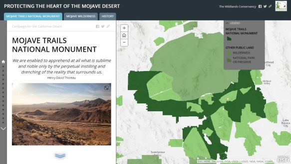
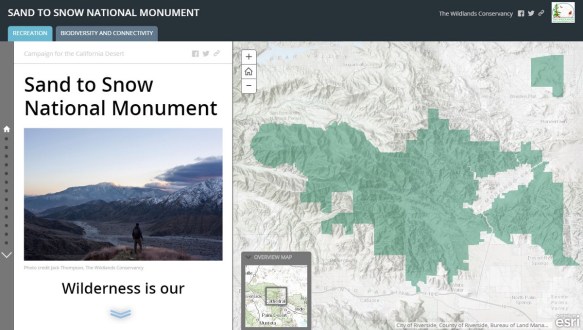
On February 12th three new areas were designated as national monuments in the California desert: Mojave Trails National Monument, Sand to Snow National Monument, and Castle Mountains National Monument.

Encompassing nearly 1.8 million acres of public lands, these new monuments are the culmination of decades of hard work and collaboration between government, conservation organizations, and local communities.

The Wildlands Conservancy played a major role in the creation of the Mojave Trails National Monument and Sand to Snow National Monument.  For the last 20 years they have acquired significant landscapes and saved them from development while stitching together California’s largest nature preserve system.

So you can better understand the new monuments, The Wildlands Conservancy has created two interactive tours of the Mojave Trails National Monument and Sand to Snow National Monument.  Check them out and go visit soon!

1on-zzint5foyuo4zaismbw

18qvjgjxwmnwnrxycfgxqtw

ArcGIS 10.4 Now Available

The ArcGIS 10.4 release is now available for all who have current licenses.  You can download the software from your my.esri.com account.

The new release includes new geoprocessing tools and updates, Python 2.7.10 with additional third-party libraries including SciPy, pandas, Sympy, and nose, and other updates to Mapping, Editing, Geodata/Geodatabases, and Network Analyst.  For more info, visit the 10.4 What’s New page.

Earth Wind Map

Check out this interactive Earth Wind Map.  The app is a visualization of global weather conditions forecast by supercomputers and updated every three hours.  You can view air currents, ocean waves and sea surface temperature, CO/CO2/SO2 surface concentrations, and air containing particulates.  You can change projections and display settings by clicking in the lower-left corner of the app.

earthwind

PostgreSQL Client Libraries for ArcGIS 10.3

After installing a PostgreSQL database to be used by our 10.3 version of ArcGIS Server and Desktop, I was looking for the PostgreSQL client libraries to install on my Windows machine.  And guess what?  There were none!

In the installs I could see the usual ones for Oracle and SQL Server, but nothing for PostgreSQL for Windows.  How am I going to use ArcCatalog to create a new Enterprise Geodatabase in PostgreSQL?

Digging around on the internet revealed that it was not needed anymore.  As explained in the ArcGIS 10.3 documentation, ArcGIS 10.3 Desktop, Server, and Engine now contain the necessary PostgreSQL client libraries.  You can now connect directly from ArcCatalog to a PostgreSQL database from ArcGIS 10.3 without having to install those pesky client libraries!

Think about that for a moment.  If you have to install ArcGIS Desktop on a bunch of user workstations, you don’t have to install the PostgreSQL client libraries as well.  It will just work.  That saves a lot of time for sure.

And think about this one … if ESRI is making sure PostgreSQL databases will work out of the ArcGIS box, what direction are they leaning toward for future Enterprise Geodatabase implementation?  They did not choose Oracle or SQL Server.  Think about that.


Web Mercator Visual and Data Analysis Fallacy

Many of you know my disdain for the Web Mercator projection.  Even the NGA in 2014 released a cease and desist regarding web mapping products for navigation and targeting due to inaccuracies.

Check out this post by Glen Bambrick as he demonstrates the problem with Web Mercator when it comes to data analysis of areas and visual presentation issues.

tissots-indicatrix_wm

The Changing Geospatial Landscape

The National Geospatial Advisory Committee released a report in December 2015 titled “The Changing Geospatial Landscape: A Second Look.”

The report states:

In this document, the committee contributes its perceptions of incipient technologies that we expect will guide, define or determine the development of this industry in the near and medium term. Of even greater importance, the report highlights those aspects of innovation that bear directly on public policy and on individual privacy and security. The NGAC has also prepared this report to help inform the development of the next iteration of the strategic plan for the National Spatial Data Infrastructure (NSDI) and the development of transition recommendations for the next Presidential administration.

You can view the report here.

GIS at Rio Hondo College

Spring semester starts first week in February at Rio Hondo College.  Course offerings can be located here: http://riohondo.isteaching.com/spring-semester-2016.html

Given a majority of our students are working, our courses are conveniently scheduled in late afternoon & evenings.  We also work closely with our civil and engineering course schedule (CAD required component of the GIS Certificate).  Rio Hondo College is located near the intersection of the 605 & 60 freeways.  We also have a class at the LA County DPW office in Alhambra.

We have a step by step process for applying for admission and registering for classes:  http://riohondo.isteaching.com/join-us/ .  New students can perform the steps entirely online.  Most classes are 4 units and last checked @46/unit.  Sign up today!

Warren Roberts GISP MLA
http://riohondo.isteaching.com/

LA and ESRI Launch LA GeoHub

Join the City of Los Angeles and ESRI via livestream on Friday, January 29, at 11 a.m. PST for an introduction of the L.A. GeoHub, a collaborative citywide data and application portal. Los Angeles Mayor Eric Garcetti and ESRI President Jack Dangermond will unveil GeoHub, built on ArcGIS, and explore the ways GeoHub empowers city employees, citizens, businesses, and NGOs to make better decisions using authoritative real-time data and map-based tools that support a thriving, dynamic community.

You can watch the livestream and the rebroadcast on YouTube.  Also take a look at the City of Los Angeles GeoHub.