Fantastic flowchart by xkcd showing how you can determine the age of an undated world map … or sometimes not!
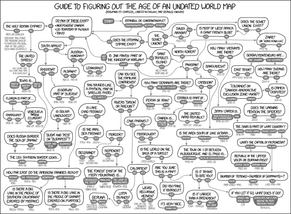

Fantastic flowchart by xkcd showing how you can determine the age of an undated world map … or sometimes not!
Beware of IP address mapping companies. They might be pointing to your house and make your life a living hell.

Just received an email that ArcGIS 10.4.1 is now available to download. If you have current maintenance, you can download it from https://my.esri.com.
Here is a list of issues addressed in the 10.4.1 release.
Jeff Orton, the President of Central Cal URISA, did a brief write-up on the CalGIS conference in Anaheim. Check it out.
Our next stop for California Friday is Gravity Hill in Sylmar. For those of you that grew up in the San Fernando Valley, you probably remember going to Gravity Hill to experience your car rolling “uphill” without any power. To make it extra creepy, it was best to experience this phenomena in the dark of night because Gravity Hill was next to a cemetery. Then add in a legend about a school bus crash that happened there and the children that died will push your car to keep you from the same fate … that makes it even more creepy! Continue reading
Didn’t get to go to the ESRI Developer Summit in Palm Springs? Here is a recap of the top technology takeaways with some videos as well. Looks like ArcGIS API 4.0 for JavaScript and Vector Tile Maps will be a big thing this year. Check it out.
The National Geodetic Survey (NGS) deployed the NOAA Office of Marine and Aviation Operation’s King Air aircraft to complete the collection of geo-referenced oblique imagery of the West Coast. More than 3,000 images were collected from the U.S.-Mexico border to Cape Flattery, WA. The imagery will be used to assess impacts of the ongoing El Niño event in several NOS mission areas, including navigation and coastal zone management. Continue reading
Our friends over at LA County have announced that the Park Needs Assessment has been published. You can download the executive summary or the full report. Continue reading
For what its worth, at least take the survey to tell them what you think of GIS certification.
For more info, see the LA County Enterprise GIS posting about it here.
Check out this article about how Google Maps has changed from emphasizing cities at the expense of roads to emphasizing the road network at the expense of cities. Also the article shows how a 1960’s era paper map does a better job balancing roads and city names.

