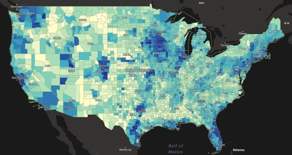
Who does your taxes? H&R Block? TurboTax? A CPA/Tax Professional? Yourself? Check out this web map by ESRI. ESRI says it used data at the census tract and block group level. It looked at whether taxpayers used H&R Block, TurboTax, a certified public accountant or other tax professional, or did their taxes on their own. ESRI then credited that block to which ever method was used the most. Click on a point and get the breakdown of tax methods.
Stuff in Space
January 2023 NOTE: The Stuff in Space website has moved. The link to the site has been updated.
Stuff in Space is a “real-time 3D map of objects in earth’s orbit”, including satellites and debris. This map uses data from Space-Track.org, a website operated by the U.S. Department of Defense. On this map, different kinds of “stuff in space” are color-coded: red for satellites, blue for rocket bodies, and grey for debris. Visitors may also explore different groups of space objects, which include maps of all Global Positioning System (GPS) satellites and their orbits and a map of the debris created by the 2009 collision of the satellites Iridium 33 and Kosmos 2251. Check it out!
Cities at Night
Astronauts on board the International Space Station (ISS) take hundreds of night-time pictures each year of cities around the globe. Cities at Night is a “citizen science project that aims to create a map, similar to Google maps, of the Earth at night using night-time color photographs taken by astronauts onboard the ISS.” Check out the photographs that have been geo-referenced to the Earth, or join in and help the project team geo-reference new photographs!
Drones Flying Free 2018
Useless FCC Broadband Map
In February the FCC released their new broadband map showing the availability of high-speed internet in the US. Many of you might remember their previous map which turned out to be completely useless. Well … this new one seems to be about the same, not matching the reality on the ground. Click below to read more about the story.
A great example of how to lie with maps. Hey! There’s a book about that! You should get it, it’s a great book.
New LA County GIO
Congratulations to Steven Steinberg on becoming the new GIO at LA County!
Before joining the County, Steven was the Principal Scientist and Department Head for Information Management and Analysis at Southern California Coastal Water Research Project (SCCWRP) a public agency for environmental research located in Costa Mesa.
Steven has extensive experience with geospatial analysis technologies including GIS, remote sensing, and image analysis in interdisciplinary applications. He has a B.S. in Natural Resources, a M.S. in Natural Resources Policy and Management, and a Ph.D. in Forestry (Geospatial Sciences). He also has co-authored books, such as GIS Research Methods: Incorporating Spatial Perspectives (2015) and GIS for the Social Sciences: Investigating Space and Place (2006).
Send Your Name to the Sun
In celebration of the summer 2018 launch of the Parker Solar Probe, NASA is inviting the public to submit their names to be added to a microchip which will be placed onboard the spacecraft.
Read more about it on Geo Lounge (click image below), which also has a link to the site for you to register your name. But hurry, you must submit your name by April 27, 2018!
Curbside Services Web App
2018 CGA Conference
If you find yourself taking a trip to Cambridge, MA in April, you might want to drop by Harvard’s Center for Geographic Analysis (CGA). CGA, together with the Harvard Data Science Initiative and ESRI, will host a conference on Illuminating Space and Time in Data Science on April 26-27, 2018. This conference aims at bringing together mainstream data scientists and geographic information scientists, to review the status of both fields, explore commonalities between the two, and identify the relevance of space and time in Data Science. The event features keynote speakers Francesca Dominici and Michael Goodchild, as well as thirty distinguished scholars from around the world. It is co-sponsored by I/UCRC Spatiotemporal Innovation Center and MapD Technologies, Inc.
This event is free and open to the public. For more information and to register, please visit http://gis.harvard.edu/events/conferences/2018-cga-conference-illuminating-space-and-time-data-science.
ESRI Updates Landsat Services
Starting April 11, 2018, ESRI will update their Landsat Image Services. Improvements include revised scaling of Top of Atmosphere (TOA) reflectance values, daily updates, new QA band, a new field to keep track of Landsat product ID, and WCS/WMS compatibility. For more info visit ESRI’s blog posting here.


