Looking for that interesting map book or atlas for the cartographic nut in your family? Or maybe for you! Check out this listing of map books that were published or are scheduled to be published in 2018, with a few in 2019.


Looking for that interesting map book or atlas for the cartographic nut in your family? Or maybe for you! Check out this listing of map books that were published or are scheduled to be published in 2018, with a few in 2019.
20 years have passed since the last atlas of desertification was published by the EU. Within that short period, the environment has undergone enormous global changes due largely to human activities. Fortunately, because of the massive increase and growth in the availability of global and regional datasets, and the tools necessary to analyze them, significant progress has been made in understanding human-environment interactions. Continue reading
Looking for a gift for someone who loves maps? Take a look at The Phantom Atlas. Long before satellites and Google, cartographers traced out maps of the world, some with errors that persisted for hundreds of years. The Phantom Atlas compiles the greatest “myths, lies and blunders” on maps, from honest mistakes to deliberate lies. Check out this interview with the author:
Hardcover and Kindle versions available on Amazon:

Eric Pimpler of Geospatial Training Services is giving away copies of his new book Programming ArcGIS Pro with Python. Enter to win a copy, just click below!

Chapters include:
Guerrilla Cartography has a kickstarter for their upcoming Water Atlas project. Contribution options include adding your location to the collaborators map, receiving a copy of the book, or even donating a copy of the book to your favorite school, library, or community center with your name printed on the inside cover. Check it out.
Thanks goes to Chandler Sterling for pointing this one out!
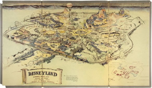
Have some extra cash? Maybe you would be interested in placing a bid for this original map of Disneyland, co-created by Walt Disney himself when the park was still in the inception phase. The map helped Walt and his brother Roy sell the park idea and make it a reality in Anaheim. For more info of the story and where the auction will be held, click below … and good luck!
And if you don’t have that kind of cash, maybe you would settle for this book instead? It’s a good one.

The book opens up from the middle, which is cool. For a look inside, check out this video.
The U.S. Environmental Protection Agency (U.S. EPA) has published a new report, Climate Change Indicators in the United States, 2016 (Fourth Edition), which includes seven new indicators and a feature on climate and health. EPA partners with more than 40 data contributors from various government agencies, academic institutions, and other organizations to compile a key set of indicators related to the causes and effects of climate change.

Mapping has been one of the most fertile areas of exploration for architecture and landscape in the past few decades. While documenting this shift in representation from the material and physical description toward the depiction of the unseen and often immaterial, Cartographic Grounds by Jill Desimini and Charles Waldheim takes a critical view toward the current use of data mapping and visualization and calls for a return to traditional cartographic techniques to reimagine the manifestation and manipulation of the ground itself. Continue reading
The capability to easily create digital contours using commercial off-the-shelf (COTS) software has existed for decades. Out-of-the-box raw contours are suitable for many scientific applications without pre- or post-processing; however, cartographic applications typically require additional improvements. For example, raw contours generally require smoothing before placement on a map. Continue reading
“Getting to Know Web GIS, Second Edition” is ESRI’s new workbook featuring detailed, step-by-step exercises that teach readers how to share resources online and build web GIS applications easily and quickly. Readers will learn how to quickly make web GIS apps using configurable app templates in ArcGIS Online; apply the ArcGIS Online cloud based analytics and smart mapping capabilities to create informative, meaningful, and beautiful maps; build 3D scenes within apps; and much more. Continue reading
