The 2020 ESRI UC is next week online! Download the attendee guide to know how to access the virtual conference, know the plenary schedule, and access sessions and other events.


The 2020 ESRI UC is next week online! Download the attendee guide to know how to access the virtual conference, know the plenary schedule, and access sessions and other events.
Thousands of people in the U.S. may be at risk from dams that are rated in poor or unsatisfactory condition. An Associated Press investigation has identified at least 1,680 dams in 44 states and the U.S. territory of Puerto Rico that are considered to be high hazard and in poor or unsatisfactory condition. A dam is listed as high hazard if its failure is likely to result in people being killed. The dams and their date of last inspection have been plotted on an interactive map. Looks like there is only 1 in California.

A new online flood risk map has been released by the nonprofit organization First Street Foundation. The online tool can tell you the current flood risk for your home and possible future risks.
The flood model used by Flood Factor is based on models of flood risk from rainfall, overflowing rivers high tides, and coastal storm surge. It takes into account such as factors as flooding history, elevation and proximity to water. To predict future risk of flooding other factors are also taken into account, such as different climate models and predicted sea level rise and predicted future precipitation patterns in the local area. Check it out!

The 2020 ESRI User Conference is next week. If you are into ArcGIS Pro, there are many events and sessions for you to attend. Click below to see a listing of live streamed events and on-demand sessions.

Planning on attending the 2020 ESRI User Conference in 12 days? Check out the current Q&A that might answer some of your questions about this particular online event.

Last year I wrote about how our datums are changing. NOAA is working on recalibrating the nation’s elevation data as part of its update to the National Spatial Reference System, expected in 2022/23. The height modernization program corrects local elevation data which has not been updated since 1988. GPS and gravity mapping are being used to update elevation. Continue reading
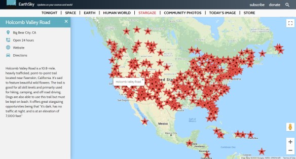
EarthSky’s interactive map will help you find the perfect spot to celebrate the summer nights as you look skyword. This resource tracks publicly accessible stargazing spots around the world. The site gathers an impressive array of locations. Visitors will find a world map with pins marking spots of interest. Click on a pin to reveal an address, directions, and a brief description. Do you have a favorite spot of your own that you want to share? The “Recommend a Place” button brings you to a submission form. Check it out!
GIS professionals are invited to take URISA on a test drive for the ‘better’ half of 2020.
Because membership dues are pro-rated according to the date of purchase, you can join now through June 30 at half-price and take advantage of member benefits for the rest of the year.
Consider individual or organization membership:
Take advantage of free and discounted education and training; professional development opportunities; and a welcoming community.
Check it out today: https://www.urisa.org/membership
ESRI has a new maps app called Field Maps. It will combine map viewing and markup, data collection and inspection, battery optimized location tracking, work planning and task management, and navigation … all for your mobile workforce needs! Check it out.

Thanks goes to Tom Lutgen at Burbank Water and Power on finding this one!
ESRI Press is releasing two a new books in July, titled Python Scripting for ArcGIS Pro and Advanced Python Scripting for ArcGIS Pro.


Like the book before them written for ArcGIS Desktop (Python Scripting for ArcGIS), these books guide you through similar exercises using ArcGIS Pro.
The Python Scripting book guides you through using Python, step by step, and will teach you how to write scripts that work with spatial data in ArcGIS Pro. You will learn to automate geoprocessing workflows, increasing efficiency and saving time. Things you will learn include:
After mastering what you learned in the Python Scripting book, you can take your scripting skills to the next level with the Advanced Python Scripting book. This book teaches you how to work with Python toolboxes, create and share script tools, manage Python packages and environments, work with Jupyter Notebook, use ArcPy and ArcGIS API for Python, and much more.
Python Scripting for ArcGIS Pro comes in both print and e-book versions, 420 pages, $79.99 retail and about $52 on Amazon for pre-orders. Advanced Python Scripting for ArcGIS Pro also comes in both print and e-book versions, 290 pages, $69.99 retail and the same on Amazon right now.
