Another interesting case, this one in Ohio about access to government GIS data. Read about it here.
Open Records Law vs GIS Data and Copyright-protected Software
Reply

Another interesting case, this one in Ohio about access to government GIS data. Read about it here.
The Southern California Geocortex User Group Meeting is today at 1:30pm in Alhambra at LA County DPW. Hope to see you all there.
Hello everyone:
USGS operates the National Map Viewer (nationalmap.gov/viewer) as a national GIS data resource. The site has long offered viewing and download access to a number of individual basemap layers (imagery, elevation, land cover, boundaries, hydrography, etc.). Recently, some new capabilities have been added providing more utility to GIS users.
1. Contour lines – the same contour lines shown on the new 1:24,000-scale US Topo can now be downloaded as vector files for use in GIS. The contour lines are available in a shapefile format. Contour lines are pre-staged in one degree blocks for quick retrieval.
2. Download Options – have been expanded to include selecting areas by a bounding box or by specifying coordinates (in decimal degrees). The site has supported the ability to download data by reference region (such as county or quadrangle or watershed) or by the map viewer extent. Now these additional options make it easier to select data for the exact region you need.
3. More maps and data to view and download – in addition to the contour lines mentioned above. National Map Viewer had added an elevation availability basemap layer which can be toggled on and off. This lets users know what resolution of elevation model is available (such as 1/3 arc-second (10m)) for a given area. Another improvement is the ability to download scanned topographic maps from the historical topographic map collection, which you will see as an option under the “available data for download window.”
We invite everyone to visit the National Map Viewer and see these new additions. And, as always, if you have any questions or need help locating or downloading data please feel free to contact us anytime. Thanks,
Drew Decker
Carol Ostergren
Now this is very interesting: Google Glass. (best viewed in Google Chrome of course)

I can see first responders using these and sending back live video and pictures.
Interesting study: Estimation of Evapotranspiration Across the Conterminous United States Using a Regression With Climate and Land-Cover Data. If you are into water management, this study is for you!
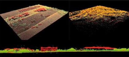
This is a great article about LiDAR data and best practices. From Earth Imaging Journal.
Also a new book on LiDAR.
In the tradition of Valentine’s Day, a heart map:

Map by Ernest Dudley Chase, 1943. You can view online at the Harvard Map Collection Digital Maps.
So you think supplying more government data freely and in more formats will lead to more use? Check out this report from the University at Albany, SUNY.
California State University Fullerton offers a Certificate in GIS. Information about the program can be found on their Extended Education site.
