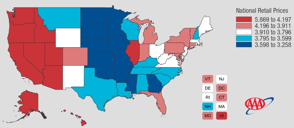
Oh California, your gas prices are too high! As of 3/29/2026, the AVERAGE California gas price is $5.869. The national average is $3.980 and climbing.
Check out the AAA Gas Price map. I think it is time to move to one of the middle states!

Oh California, your gas prices are too high! As of 3/29/2026, the AVERAGE California gas price is $5.869. The national average is $3.980 and climbing.
Check out the AAA Gas Price map. I think it is time to move to one of the middle states!
SWCA Environmental Consultants is seeking a GIS Specialist to support our Southern California – Pacific Islands sub-region including our businesses in So Cal, Nor Cal, and Hawaii. SWCA’s GIS Department consists of approximately 80 GIS Professionals with diverse backgrounds in GIS design, cartography, data management, and more. This position will primarily support both our Natural and Cultural Resource programs in Southern California, CalPac sub-region, and will collaborate with and support other SWCA offices across the country as well.
This is an entry-level regular, full time, hourly position paying $25.26- $32.18 an hour. The position will be based in Pasadena, CA. Hybrid and remote work environments are available.
For more info and to apply, visit https://www.swca.com/careers/current-openings/gis-specialist-14504/
Dear Colleagues,
I am reaching out to share a consulting opportunity with the University of Nevada, Reno Libraries. As the Earth Science GIS & Maps Librarian at UNR, I’m leading a strategic planning grant for a statewide Nevada Historical and Environmental Geospatial Repository, a project funded by IMLS through a LSTA grant.
This initiative represents the first phase of a long-term vision to build a public, statewide digital resource that provides improved access to historical and environmental maps and geospatial data for researchers, educators, state agencies, tribal organizations, and the broader public across Nevada.
I’m seeking someone with experience with geospatial platform development to serve as a Geospatial Repository Consultant. The consultant will advise on technical design, metadata standards, infrastructure planning, and sustainability strategies, and will contribute directly to the development of the strategic plan’s final report.
Compensation: $125/hour | 100 hours total
Engagement: project-based for 4 – 6 months
Location: Remote
I am looking for someone with hands-on experience in geospatial platform development, digital repository design, or GIS infrastructure planning, ideally in an academic, library, or institutional setting. Has experience working collaboratively with faculty, librarians, or state/tribal partners.
If you or someone you know may be a good fit, I would love to connect. Please feel free to reach out directly or forward this message to relevant colleagues and networks. Interested candidates are welcome to send a brief statement of interest and CV to:
Chrissy Klenke – cklenke@unr.edu
A full position description is available upon request. I am happy to answer any questions about the project, the scope of work, or the application process.
GIS Analyst Job Posting – Helix Water District – $112,944-$144,164/annually
HELIX WATER DISTRICT is a progressive public water agency and an industry leader, providing high-quality water through an efficient, reliable system. Behind that system is a talented team of people who care deeply about public service, technical excellence, and doing work that actually makes a difference! We are looking for an experienced GIS Analyst who feels the same way.
The GIS Analyst role is for someone who loves the craft of GIS, enjoys solving real-world problems, and wants their work to have a direct impact on residents, businesses and the environment by connecting people, systems and trusted data. Great public service runs on current, reliable information – and GIS is at the center of it!
WHY CHOOSE HELIX?
Our organization thrives on a culture built around collaboration, respect and genuine care for every individual’s growth. We believe that when people are supported, and inspired, they can achieve their best work. Our benefits go beyond the basics, offering comprehensive health coverage, professional development programs and wellness initiatives designed to help our team flourish both personally and professionally. Choosing Helix means joining a community that celebrates your contributions, invests in your future and empowers you to make a meaningful impact. Benefits include
– Competitive Salary: $112,944 – $144,164/annually
– 100% employee premiums paid for all health benefits
– Annual Merit Increases. Full-time employees are eligible for 5% merit increases on an annual basis until they reach the top of their pay range
– CalPERS membership
– Deferred Compensation. Up to $3,500 matching on 457 plan
– 24 annual days of accrued leave (Increases to 29 after 5 years of service, max 37 annual days of accrued leave)
– 12 paid holidays per year including 2 floating holidays
– Education Reimbursement up to $4,000 annually for qualifying coursework after one year of employment
Overview of Responsibilities
As our GIS Analyst, you’ll help keep the District’s GIS accurate, relevant, and genuinely useful by working at the intersection of people, technology, and public service. This role is about more than managing data—it’s about building relationships, understanding how teams do their work, and turning that understanding into GIS tools and information they can rely on.
You’ll collaborate with staff across the organization to translate real needs into thoughtful GIS solutions, maintaining high-quality enterprise data and developing applications, automations, and workflows that make information easier to access, update, and trust. You’ll help ensure the integrity of GIS data and systems, integrate GIS with other enterprise platforms, and support both internal users and the public through clear documentation, training, and technical guidance.
To be considered for the GIS Analyst, please visit hwd.fyi/careers.
The Library of Congress will hold a webinar on Nautical Charts.
Geography & Map Virtual Orientation: Nautical Charts
Date & Time: Feb 10, 2026 12:00 PM (PST)
Description: Reference librarian Julie Stoner and geospatial data visualization librarian Abraham Parrish will present an introduction to nautical charts in the Geography and Map Division collections at the Library of Congress. The first half of this orientation session will give an introduction to nautical charts, their history, and their uses. The second part of the orientation will highlight the various nautical chart holdings found within the division and how to search for and view these maps. After the presentation, staff look forward to answering additional questions from attendees.
I wanted to say Merry Christmas to all and share the Merry Christmas Map (v2) from ESRI. The web map provides a detailed basemap for the world symbolized with a unique twist on the Christmas holiday. Check it out!
Registration for the 2026 ESRI User Conference in San Diego is now open! Get registered and find your favorite hotel!

The next Cambridge Seminar in the History of Cartography will be held via Zoom on Tuesday 18 November 2025 at 5.30pm UK time (9:30am PST).
The speaker will be Chris Lukinbeal, University of Arizona on Cinematic Cartography.
All are welcome.
Please register for the talk at https://buytickets.at/emmanuelcollege/1929457 and the Zoom link will be sent to you.
**********
On a side note, this reminds me of a book I purchased a while back, Cinemaps. You should pick one up for a Christmas gift! -mike

The California Geographic Information Association will have their annual meeting on Thursday, November 20th 12-1:30pm.
For more information visit https://cgia.org/2025/11/join-us-for-the-cgia-annual-meeting-on-november-20-2025-12-130-pm/
GIS Technician – City of Hesperia
GIS Supervisor – City of Corona
Enterprise GIS & CAD Team Manager – Los Angeles
BIM/GIS Coordinator III – Pasadena
Principal Instructor ArcGIS Enterprise – Redlands
GIS Technician/Analyst – Anaheim
GIS Mapping Technician – San Marino
Engineering Technician I (GIS) – City of Torrance
