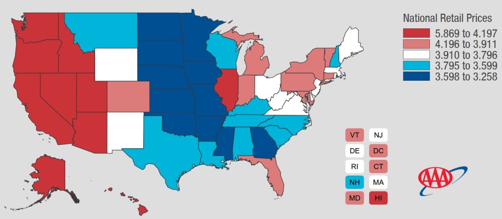
Oh California, your gas prices are too high! As of 3/29/2026, the AVERAGE California gas price is $5.869. The national average is $3.980 and climbing.
Check out the AAA Gas Price map. I think it is time to move to one of the middle states!

Oh California, your gas prices are too high! As of 3/29/2026, the AVERAGE California gas price is $5.869. The national average is $3.980 and climbing.
Check out the AAA Gas Price map. I think it is time to move to one of the middle states!
SWCA Environmental Consultants is seeking a GIS Specialist to support our Southern California – Pacific Islands sub-region including our businesses in So Cal, Nor Cal, and Hawaii. SWCA’s GIS Department consists of approximately 80 GIS Professionals with diverse backgrounds in GIS design, cartography, data management, and more. This position will primarily support both our Natural and Cultural Resource programs in Southern California, CalPac sub-region, and will collaborate with and support other SWCA offices across the country as well.
This is an entry-level regular, full time, hourly position paying $25.26- $32.18 an hour. The position will be based in Pasadena, CA. Hybrid and remote work environments are available.
For more info and to apply, visit https://www.swca.com/careers/current-openings/gis-specialist-14504/
Dear Colleagues,
I am reaching out to share a consulting opportunity with the University of Nevada, Reno Libraries. As the Earth Science GIS & Maps Librarian at UNR, I’m leading a strategic planning grant for a statewide Nevada Historical and Environmental Geospatial Repository, a project funded by IMLS through a LSTA grant.
This initiative represents the first phase of a long-term vision to build a public, statewide digital resource that provides improved access to historical and environmental maps and geospatial data for researchers, educators, state agencies, tribal organizations, and the broader public across Nevada.
I’m seeking someone with experience with geospatial platform development to serve as a Geospatial Repository Consultant. The consultant will advise on technical design, metadata standards, infrastructure planning, and sustainability strategies, and will contribute directly to the development of the strategic plan’s final report.
Compensation: $125/hour | 100 hours total
Engagement: project-based for 4 – 6 months
Location: Remote
I am looking for someone with hands-on experience in geospatial platform development, digital repository design, or GIS infrastructure planning, ideally in an academic, library, or institutional setting. Has experience working collaboratively with faculty, librarians, or state/tribal partners.
If you or someone you know may be a good fit, I would love to connect. Please feel free to reach out directly or forward this message to relevant colleagues and networks. Interested candidates are welcome to send a brief statement of interest and CV to:
Chrissy Klenke – cklenke@unr.edu
A full position description is available upon request. I am happy to answer any questions about the project, the scope of work, or the application process.
