For Valentine’s Day this year, enjoy this old world map in a double cordiform map projection. Published by Antonio Lafreri, c. 1564.
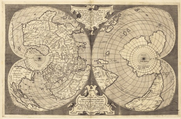

For Valentine’s Day this year, enjoy this old world map in a double cordiform map projection. Published by Antonio Lafreri, c. 1564.
Most of us using GIS today do not get to do much mapping of whales, but back in the mid 19th century the American whaling trade was big business and you needed to know where the whales were.
Check out this innovative map from 1851 showing the distribution of several different species of whales, identifying each with a combination of color and pictorial symbols. The map shows at that time that the Pacific Ocean was the primary habitat for whales. The Atlantic Ocean was not because the whale resources there had been terribly depleted. Check it out!

Great funny map from xkcd.com:

Is the risk of wildfires increasing where you live? Check out this article about analyzing US Forest Service data and the threat of fire breaking out in areas that would be difficult to contain.

This interesting animation of Earth shows a year of seasons in 1 second. Besides the usual snow in the north, note the green vegetation that fluctuates over the year. This animation was created from monthly images in NASA’s Blue Marble project.

CalGIS 2019 will be the milestone 25th annual gathering of the GIS community in California. It will take place April 8-10 at the DoubleTree Hilton in Fresno. Click below to review the agenda. Early bird registration and sponsorship discounts until February 15.

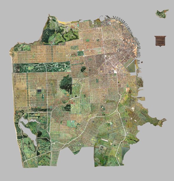
Found this interesting digital map of San Francisco in the David Rumsey Map Collection. It was a massive wooden model of San Francisco that has not been on display in one piece since 1942. The 158 pieces that create a 42×38 foot model of the city were digitally photographed and pieced together to create one big mosaic image. The model represented the city as it was in 1940. Check it out!
This year the ArcGIS User Seminar will be in the SoCal area this Thursday in Glendale. This free half-day seminar basically covers what’s new in ArcGIS software and demonstrates tips and tricks, use cases, and gives you a vision and techniques for maximizing the potential of your GIS. Check it out.
Need to fulfill a beginning GIS requirement? Or just want to expand your knowledge and learn a new skill? Then come join me at College of the Canyons and sign up for GIS 101, Introduction to Geographic Information Systems. I promise you the class will be challenging and rewarding! Also, your earned units are UC/CSU transferrable.
GIS 101 is filling up quickly, so register for the Spring semester as soon as possible. The GIS class will meet at the Valencia campus every Tuesday from 6:30pm to 9:35pm, February 5 to May 28. We start next week!
Feel free to contact me, Michael Carson (michael.carson@canyons.edu), if you have any questions.
Many of us that create GIS data and share with others have no idea of the unintended consequences that the data might produce. Using data and ignoring the scale, resolution, accuracy, and where it came from might produce very wrong results.
Click below to read this rather long story about how location data married with IP addresses is causing a horror show for a couple in South Africa, and this is not the only case.