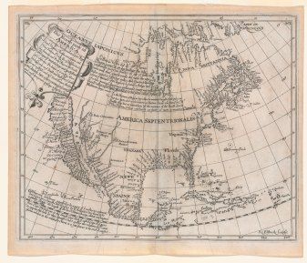
 This 1625 map by British mathematician Henry Briggs initiated one of the most famous of all cartographic misconceptions, California as an island, which persisted until the end of the 17th century. This idea is thought to have originated with the Carmelite friar, Antonio de la Ascension who accompanied Sebastian Vizcaino on his West Coast expedition of 1602-03, and wrote an account of the trip. About 1620, it is believed that Father Ascension drew a map depicting California as an island and dispatched it by ship to Spain. The ship was captured by the Dutch and the chart taken to Amsterdam.
In 1622, California appeared as an island on two title page vignettes published in Amsterdam by Michiel Colijon: Jacob le Maire’s Spieghel Der Australische Navigatie and Antonio de Herrera’s Descriptio Indw Occidentalis. That same year in London, Henry Briggs published an article entitled “A treatise of the Northwest Passage to the South Sea, through the Continent of Virginia, and by Fretum Hudson.” Briggs claimed to have seen a map in London brought from Holland showing California as an island. His article was republished slightly modified in 1625 in Purchas’ Pilgrimes, and was accompanied by this map supposedly drawn from the one “taken by Hollanders.” A similar map engraved by Abraham Goos was inserted into a small book published in 1624 in Amsterdam. Although dated earlier, it is likely that this map used the Briggs map as a source.
Briggs’ map quickly became a model for others. John Speed copied it in 1626-7 as did Joannes Jansson in 1638, and soon nearly all European cartographers depicted California as an island. One purpose of the map was to suggest the probability of a short passage from Hudson Bay to the Pacific Ocean, which was enhanced cartographically by the absence of a northern coast and land to the west, which were common features of maps up to that time.
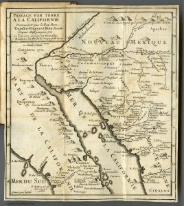
 A Jesuit friar, Eusebio Kino, was the first to offer proof against the island theory using the map he compiled in 1701, which was printed in 1705 in Paris. Kino’s map was not readily accepted and it eventually required a royal decree by Ferdinand VII of Spain in 1747 to state that “California is not an Island.”
(text from CaliforniaMapSociety.org)

The reaction against Kino’s map “Passage Par Terre A La Californie” was intense and vicious in Europe – it was probably best summed up in Herman Moll’s (a prominent London cartographer) 1711 proclamation: “Of course California is an island – why, I have had mariners in my office who have sailed around it!” -Tony Arioli